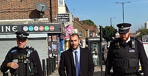
 Enfield Labour welcomes new court order to stop antisocial behaviour in Edmonton Green
 David Lammy arrives in Downing Street after becoming deputy prime minister
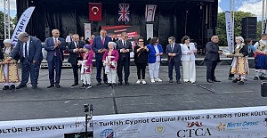 CTCA UK Condemns the Political Forcing Out of Afzal Khan MP for Engaging with Turkish Cypriots
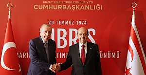
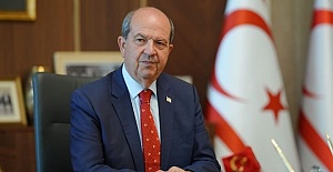 Tatar: “Reaction to MP’s TRNC visit is yet another stark example of the Greek Cypriot leadership’s primitive and domineering mentality”
 Enfield Labour Calls for Public Feedback on Crime and Safety Concerns
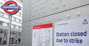 Important Travel Updates: London Underground and DLR Strike Action
 Team Enfield ranks fifteenth the in London Youth Games
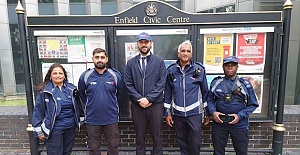 Parking enforcement boosted with more officers on patrol in Enfield
 Liverpool flew out for their Champions League match against Galatasaray
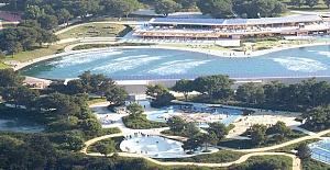 Enfield Council has approved plans for Surf London
 Zlatan Ibrahimović receives UEFA President’s Award
 UEFA Europa League and UEFA Conference League draws to be combined into one single show
 Enfield’s Crews Hill and Chase Park shortlisted for potential New Town
 Important milestone achieved with no hotel placements for temporary accommodation
 London tube strike shuts down services as TfL website crashes
 HMRC TARGETS ERRORS IN MARGINAL RELIEF CLAIMS


In the spring of 2011 Turkish Prime-Minister Erdoğan organised a press conference and announced with – even to his standards – exceptional bombast his personal plans for the construction of a second Bosporus channel[1]. Matching complete grandeur with complete insanity, this new channel – 50 kilometres long, 150 meters wide and 25 meters deep – should be completed on the hundredth birthday of the republic in 1923.
In the realm of social sciences spatial dimensions are often neglected or at best treated as a given stage on which social and historical developments are simply carried out. However – as the abovementioned anecdote shows and as it is also argued here – the specific form that spatial organisation takes, is often connected to political and economic relations. From this perspective spatial organisation is not neutral, but instead inherently part of political-economic structures.
Historical Geography of Capitalism
From the 1960s onwards the academic discipline of human geography has witnessed a shift towards a more socially embedded interpretation of space. This predominantly Marxist reorientation – led by geographers such as Henri Lefebvre, David Harvey and Doreen Massey – emphasised the interconnectedness of spatial formations and social relations[2] within a particular mode of production. What was meant here is that space and social relations are interconnected and mutually reflecting each other. In this way, space is a product of existing social relations and in order to analyse the latter and the associated mode of production, one has to take spatial formations into consideration. In other words, overarching political-economic structures influence how space or cities look like. In the specific case of a capitalist society, this relation can be seen in the characteristics of capitalist production, consumption and exchange that are reflected in the spatial environment. In the following parts this geography of capitalism will be engaged with in a Marxian understanding.
First of all, it must be understood that the capitalist mode of production is directed by the drive for surplus value, or profits. With an initial stock of money a capitalist can buy commodities such as labour power and other means of production, in order for them to engage in the production process and produce new commodities which can be sold for more value than the initial input. The profit then can be reinvested in the same cycle, causing this sequence to repeat itself indefinitely in a growing spiral manner. Without this circulation no surplus value would be created and the system would collapse. To facilitate this process in an optimal way, space must be organised conveniently to speed up the turn-over time of capital and to take away potential restraints to these circuits. Centralised factories, infrastructure, or cities for that matter, are evident examples where spatial constraints to capital accumulation are being minimised. David Harvey calls this spatial solution to problems in the sphere of optimal accumulation the “spatial fix”[3].
In addition to this spatial organisation for the sake of optimal profit generation, the asymmetric results of this profit-led logic are also reflected in spatial structures and, as above, this influences the way cities are shaped. This uneven economic structure, resulting into concentration and centralisation of wealth, is being projected onto patterns of uneven spatial organisation. This results in a highly dichotomous spatial reality: creating well-equipped networks competing in the global sphere next to spaces of stagnation and decline; accommodating concentrated prosperity, tourism and frantic consumption alongside forgotten places of destitute outside of the connected core. All in all, the particular mode of production under capitalism influences space in a particular way. In this respect, one could speak of capitalist space, or a capitalist city, as a distinct category.
In the next part this theoretical framework will be applied to the case of spatial structures and regeneration in Istanbul.
Spatial Transformation in Istanbul
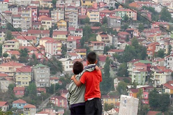
On the crossroads of Asia and Europe the imperial city of Istanbul has always been an important urban node. A metropolis for over a millennium, Istanbul experienced a rapid demographic growth after the Second World War, turning itself into one of the world’s largest metropolitan areas, inhabited by almost fifteen million people. From the 1980s onwards, when Turkey embarked on an extensive restructuring of its economy based on neoliberal principles[4], Istanbul experienced an important political-economic transformation. As the most important city, Istanbul was to be the crown jewel of this economic restructuring, competing with other cities around the world for the favours of global capital. This economic restructuring had, as elaborated on in the previous part, a spatial dimension as well. Former public land was being privatised and sold, old neighbourhoods were demolished on a large scale to make way for more profitable purposes, manufacturing was decentralised and replaced to the outskirts of the city leaving the former employees unemployed and misplaced, infrastructure around the business centres was improved and the finance and tourism sector were embraced and prioritised.
As stated in the theories before, the asymmetric economic and social patterns generated by this intensification of capitalist production, were reflected in an uneven development of the urban space. Some neighbourhoods – like Şişli in the north and the gated communities along the shores of the Bosporus – are very rich, while half of the population (!) lives in so-called gecekondu (“overnight built”) slums such as Sulukule and Tarlabaşı. Other neighbourhoods – like the former European and long neglected neighbourhoods of Galata, Cihangir and Tophane – are rapidly gentrified, separating the rich from the poor by displacing the poor from the old inner-city areas[5].
Another important implication for the city’s spatial organisation comes from the economic priority that was given to large business, finance, up-market consumption and tourism. While the infrastructure of the historic peninsula was restructured to serve the millions of tourists visiting Istanbul every year, the infrastructure of the central business districts of Levent and Maslak were equipped with quick rail and road connections and a first – and later a second – Bosporus-spanning bridge into Asia[6]. In these areas business towers, luxury hotels and shopping malls rose, while waterfronts were redeveloped and parks laid out. This restructuring was essential if Istanbul was to be able to compete with other global cities looking to attract investment from commercial and tourist sources. In other words, this spatial restructuring was inevitably connected with the logic of the overarching economical system of neoliberal capitalism.
In the last part two specific examples of such spatial restructuring within Istanbul will be laid out.
The Transformation of Beyoğlu
Beyoğlu is the old European neighbourhood of Istanbul, beautifully located between the Bosporus and the Golden Horn. After the dissolution of the Ottoman Empire and the departure of the former bourgeoisie, the neighbourhood fell into neglect and disarray. Since the 1990s however, the neighbourhood presents itself as the pulsing heart of modern Istanbul. An essential development here was the restructuring of the Istiklal Avenue, the main shopping street. By turning this old dilapidated European grand rue into a pedestrian walk and by transforming the manufacturing workshops into elegant shopping windows, a new impulse was given to whole area. Its proximity to the central business districts in the north and improved transport options connecting the two of them – a parallel highway was constructed, just as a second municipal metro line – transformed the neighbourhood into a very desirable residential area. This was reinforced by the renewed potential for consumption, shopping, tourism and nightlife together with the attractive historical legacy of the area[7]. The restructuring of the area around the Istiklal Avenue spilled over to other surrounding neighbourhoods – such as Cihangir, Galata, Şişhane and Tophane – which enjoyed the same advantages and could ride the wave of spatial regeneration.
In this way, this particular development in Beyoğlu can be seen as a textbook example of spatial regeneration on capitalist foundations. Old spaces of small scale manufacture and low-market residence, were transformed in profitable areas of consumption, up-market residence and tourism, well equipped and well connected to optimally facilitate the circulation of capital.
Port of the Orient: Galataport
A second example of urban restructuring is the project of the still to be constructed cruise ship harbour at the Bosporus shore of Karaköy and Galata. In this plan, 1.2 kilometre of shore will be redeveloped into a strip of cruise terminals, shopping malls, banks, luxury hotels and some enormous docks. A new tramline will connect the port with the Old City in the south, the central business districts in the north and the various hotels along the quay. In addition, new privatised fast ferry lines will be introduced to connect the port with the rest of the city and the Asian parts. In order to implement these plans, the now still public shoreline will have to be privatised[8].
This example of an urban mega project clearly shows how Istanbul wants to present itself on the stage of global capital. Projects like this aim to optimally accommodate potential international investments and as such are indispensable in the ongoing competition with other ‘global cities’. In the long run, by constructing a large and convenient port it literally opens its doors to potential investors and masses of tourists, while polishing the city’s image as a ‘port of the Orient’. The direct benefits on the other hand include large scale investments of large hotel corporations, banks and construction companies. Put differently and linking it to the earlier theoretical framework, a whole new round of capital circulation can be initiated by building these new up-market spatial structures from scratch.
Concluding
It was argued here that spatial organisation and social relations are interconnected and mutually reflected in each other. In the case of a capitalist society this can be witnessed in the way capitalist logic and associated social relations take concrete shape in the spatial environment. Social relations of capitalist production produce space and spatial organisation in its turn reproduces capitalist social relations. To support this claim, the experience of urban spatial restructuring in Istanbul was deconstructed and analysed.
It is important to understand however, that the kind of spatial (re-) generation witnessed in the case of Istanbul, is not only inseparably connected with the logic of capitalist production, but actually indispensable for its survival. As stated before, capitalism is a circular system in continuous motion, where capital needs to be invested, reinvested and constantly circulated. Spatial structuring and restructuring are very important components of the way this circulation is being continued.
On a final note however, this dependence on continuous ‘spatial fixes’ for its survival also puts this particular mode of production in a vulnerable position. Without spatial formations facilitating and ‘fixing’ capitalist circulation every now and then, the capitalist mode of production might well be seriously hindered in its reproduction. And if this is the case and capitalist social relations are indeed highly interconnected with and dependent on spatial structures, these same spatial structures might well be a key in trying to oppose the capitalist mode of production altogether. Confronting and reclaiming space as a strategy for social change – as for instance the Occupy movement has done – provides dissenting and resisting movements with a spatial dimension as well. In other words, just as the incumbent hegemonic powers are dependent on space for their survival, social change too can be arrived at by taking control of space. “Whose streets…?”
Mirko van Pampus
Please cite this publication as follows:
Van Pampus, Mirko (August, 2012), “Spatial Transformations in Istanbul”, Vol. I, Issue 6, pp.24-31, Centre for Policy Analysis and Research on Turkey (ResearchTurkey), London, ResearchTurkey. (http://researchturkey.org/?p=1764)
[1] A ‘second Bosphorus’ to be built in Istanbul’. Hurriyet Daily News [online] 27.04.2011.
[2] In Marxian vocabulary “social relations” comprise the relations between abstract groups within society based on their relative position within the capitalist production system. They form the organic micro-structure of a capitalist society. Although Marx in this way emphasised the social foundations of a particular mode of production, these social relation naturally include the political and economic relations of the capitalist society.
[3] Harvey, D. 1985. ‘The Geopolitics of Capitalism’. In: D. Gregory & J. Urry (Eds.),Social Relations and Spatial Structures, 128-163. London: MacMillan.
[4] This included among other things the liberalisation of the labour market, the capital account and trade, and the deregulation and privatisation of large parts of the public sector. All this was part of an IMF-led development strategy based on neoliberal economic convictions and its implementation was severely supported by the military coup of 1980.
[5] Karaman, O. 2008. ‘Urban Pulse – (Re)Making Space for Globalization in Istanbul’. Urban Geography 29(6): 518-527.
[6] Ergun, N. & B. Dundar. 2004. ‘Functional Change as an Indicator of Transformation near the old City Centre of Istanbul’. European Planning Studies 12(5): 723-738.
[7] Dökmeci, V., U. Altunbaş & B. Yazgı. 2007. ‘Revitalisation of the Main Street of a Distinguished Old Neighbourhood in Istanbul’. European Planning Studies 15(1): 153-166.
[8] Karaman, O. 2008. ‘Urban Pulse – (Re)Making Space for Globalization in Istanbul’. Urban Geography 29(6): 518-527.